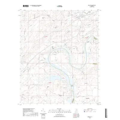
2018 Map of Ragland
USGS Topo · Published 2018About this map
Riverside and Lincoln occupy the southern reaches of this survey, where the Coosa River broadens into the expansive Logan Martin Lake. The landscape is defined by the river's winding path through the Alabama countryside, creating distinctive features such as Embry Bend and Kirkseys Bend. To the north, the terrain rises toward Henderson Mtn and Mitchell Mtn, with Starvation Valley tucked between the ridges. The settlement of Ragland is positioned near the northeastern corner, surrounded by smaller watercourses like Trout Cr and Green Br.
Find a feature on this map
108 named features on this map. Tap any name to fly to it.
Don’t see what you’re looking for? This feature index may not catch every label — zoom into the map to look around manually.
Map Details
Editions of this 2018 Ragland Map
This is the sole edition of this map. No revisions or reprints were ever made.
Other maps of this area

1889 · Springville
USGS Topo · 1:125,000

1892 · Springville
USGS Topo · 1:125,000

1947 · Cox Gap
USGS Topo · 1:24,000

1947 · Eastaboga
USGS Topo · 1:24,000

1947 · Ragland
USGS Topo · 1:62,500

1947 · Ragland
USGS Topo · 1:24,000

1947 · Riverside
USGS Topo · 1:24,000

1947 · Francis Mill
USGS Topo · 1:24,000

1947 · Steele
USGS Topo · 1:62,500
1949 · Ohatchee
USGS Topo · 1:24,000