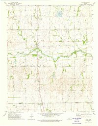
1973 Map of Rago
USGS Topo · Published 1975About this map
The Chikaskia River winds through south-central Kansas, carving a path across a landscape defined by agricultural sections and early energy extraction. The small settlement of Rago serves as a central junction where the Atchison Topeka and Santa Fe railroad meets local thoroughfares, while further south, the community of Duquoin sits on the border of Kingman Co and Harper Co. This mid-1970s record highlights a transition toward industrial land use, evidenced by a large Gas Field and a dedicated Gas Storage Area.
Find a feature on this map
28 named features on this map. Tap any name to fly to it.
Don’t see what you’re looking for? This feature index may not catch every label — zoom into the map to look around manually.
Map Details
Editions of this 1973 Rago Map
This is the sole edition of this map. No revisions or reprints were ever made.
Other maps of this area

1889 · Anthony
USGS Topo · 1:125,000

1889 · Cheney
USGS Topo · 1:125,000

1889 · Caldwell
USGS Topo · 1:125,000

1891 · Cheney
USGS Topo · 1:125,000

1891 · Anthony
USGS Topo · 1:125,000

1892 · Kingman
USGS Topo · 1:125,000

1893 · Caldwell
USGS Topo · 1:125,000

1894 · Kingman
USGS Topo · 1:125,000

1897 · Caldwell
USGS Topo · 1:125,000

1901 · Cheney
USGS Topo · 1:125,000