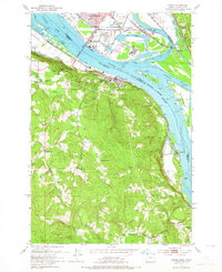
1953 Map of Rainier
USGS Topo · Published 1965About this map
The Columbia River serves as the dominant geographic and economic spine of this 1950s landscape, separating the industrial activity of Longview, Washington, from the timbered slopes of Rainier, Oregon. Along the northern bank, heavy industry is concentrated at the Port of Longview and a large Sawmill near the Log Pond, while the U S Naval Reserve Training Center marks the riverfront. On the Oregon side, the terrain rises sharply from the water, characterized by named peaks like Fern Hill and the winding Beaver Valley. Rural life is anchored by several local institutions, including the Knights of Pythias Cem and various schools such as Hudson Sch and the Fernhill Sch (Aband). Downstream, the river bifurcates around Cottonwood Island through the Carrolls Channel and Slaughters Channel, passing small river-adjacent communities like Prescott and Goble.
Find a feature on this map
57 named features on this map. Tap any name to fly to it.
Don’t see what you’re looking for? This feature index may not catch every label — zoom into the map to look around manually.
Map Details
Editions of this 1953 Rainier Map
4 editions found

Other maps of this area

1919 · Mayger
USGS Topo · 1:62,500

1921 · Kalama
USGS Topo · 1:62,500

1922 · St. Helens
USGS Topo · 1:62,500

1940 · Vernonia
USGS Topo · 1:62,500

1941 · St Helens
USGS Topo · 1:62,500

1941 · Clatskanie
USGS Topo · 1:62,500

1943 · Vernonia
USGS Topo · 1:62,500

1943 · St Helens
USGS Topo · 1:62,500

1948 · Vancouver
USGS Topo · 1:250,000

1950 · Vancouver
USGS Topo · 1:250,000