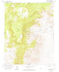
1961 Map of Rainier Mesa
USGS Topo · Published 1978About this map
Rainier Mesa and the surrounding high desert of Nye County appear here as a landscape shaped by specialized industrial and scientific activity during the early 1960s. Surveyed in cooperation with the Atomic Energy Commission, the map details the infrastructure of the Nevada Test Site, including the administrative and operational boundaries of Area 12, Area 14, and Area 2. Grounded in a complex network of topographical features like The Aqueduct Mesa and the Eleana Range, the map documents specific facilities such as a Radioactive Waste Dump, a High Explosive Test Area, and High Explosive Storage. Amidst this modern technical development, traditional desert landmarks remain, from Gold Meadows to vital water sources like Whiterock Spring and Captain Jack Spring. The terrain is navigated by a sparse system of the Mesa Road and numerous Jeep Trails cutting through Tongue Wash and Stockade Wash.
Find a feature on this map
27 named features on this map. Tap any name to fly to it.
Don’t see what you’re looking for? This feature index may not catch every label — zoom into the map to look around manually.
Map Details
Editions of this 1961 Rainier Mesa Map
2 editions found
Other maps of this area

1908 · Kawich
USGS Topo · 1:250,000

1942 · Wheelbarrow Peak
USGS Topo · 1:125,000

1952 · Tippipah Spring
USGS Topo · 1:62,500

1952 · Timber Mountain
USGS Topo · 1:62,500

1952 · Wheelbarrow Peak
USGS Topo · 1:62,500

1952 · Silent Canyon
USGS Topo · 1:62,500

1954 · Goldfield
USGS Topo · 1:250,000

1955 · Goldfield
USGS Topo · 1:250,000

1958 · Goldfield
USGS Topo · 1:250,000
1960 · Yucca Flat
USGS Topo · 1:24,000