
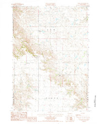
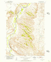
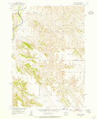
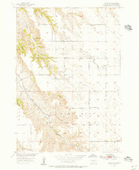
1984 Map of Rainy Creek
USGS Topo · Published 1994About this map
Creighton Community Hall serves as a lonely social anchor in this sparsely populated stretch of western South Dakota, situated among the high plains and dissected plateaus of Pennington County. The landscape is defined by its drainage systems and prominent landforms, including Cedar Butte and the vast Ash and Huron plateaus. Water is the primary architect of the terrain, with the North Fork Rainy Creek, Deep Creek, and Bull Creek cutting deep, meandering paths through the grassland. A small Landing Strip and the isolated Willuwelt Ranch illustrate the logistical realities of ranching life in the late 1970s and early 1980s, where distance and terrain dictated the placement of infrastructure. The map reflects a period of meticulous aerial survey, capturing the exact contours of the Sunnyside and Pen O ranges before more modern development reached the area.
Find a feature on this map
14 named features on this map. Tap any name to fly to it.
Don’t see what you’re looking for? This feature index may not catch every label — zoom into the map to look around manually.
Map Details
Editions of this 1984 Rainy Creek Map
2 editions found
Other maps of this area

1953 · Rapid City
USGS Topo · 1:250,000
1954 · Dalzell SE
USGS Topo · 1:24,000
1954 · Wasta NE
USGS Topo · 1:24,000
1954 · Wasta SE
USGS Topo · 1:24,000

1955 · Creighton
USGS Topo · 1:24,000

1955 · Pedro SE
USGS Topo · 1:24,000

1957 · Rapid City
USGS Topo · 1:250,000

1983 · Horse Tooth
USGS Topo · 1:24,000

1983 · Elm Creek Ranch
USGS Topo · 1:24,000

1983 · Lake Hill
USGS Topo · 1:24,000