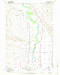
1967 Map of Rairden
USGS Topo · Published 1971About this map
The Bighorn River carves a deep meandering path through the arid landscape of the Big Horn Basin, creating a fertile corridor defined by an intricate network of irrigation systems. Settlements like Rairden and Eccles are positioned along the Burlington Northern railroad, which parallels the river's eastern bank. The map reveals the critical importance of water management in this region, showing the extensive reaches of the Bighorn Canal, Fritz Canal, and the Upper Hanover Canal. These man-made waterways contrast sharply with the dry drainages of Alamo Creek and Sixmile Creek. Beyond the agricultural zones, the landscape is dotted with signs of natural resource extraction, including numerous Oil Wells and a Gravel Pit, particularly north of the Big Horn and Washakie county line.
Find a feature on this map
18 named features on this map. Tap any name to fly to it.
Don’t see what you’re looking for? This feature index may not catch every label — zoom into the map to look around manually.
Map Details
Editions of this 1967 Rairden Map
2 editions found
Other maps of this area

1951 · Schuster Flats NE
USGS Topo · 1:24,000

1951 · Schuster Flats SE
USGS Topo · 1:24,000

1955 · Cody
USGS Topo · 1:250,000

1955 · Sheridan
USGS Topo · 1:250,000

1958 · Cody
USGS Topo · 1:250,000

1958 · Sheridan
USGS Topo · 1:250,000

1960 · Manderson
USGS Topo · 1:24,000

1960 · Manderson SE
USGS Topo · 1:24,000

1962 · Sheridan
USGS Topo · 1:250,000

1962 · Cody
USGS Topo · 1:250,000