
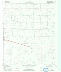
1967 Map of Ralls NE
USGS Topo · Published 1968About this map
The High Plains of Crosby County are defined here by a vast grid of agricultural development and water infrastructure during the late 1960s. The landscape is marked by a high density of irrigation points, simply labeled Well, which sustained the cotton and grain fields of this Llano Estacado region. Transportation and logistics are centered on the Atchison Topeka and Santa Fe railroad, which runs parallel to a major 4 Lane highway connecting the settlements of Ralls and Crosbyton. Small rural nodes like Fairview Sch suggest the earlier patterns of local community life before the further consolidation of regional districts. The presence of a Gravel Pit and a local Landing Strip reflect the industrial and aerial accessibility of the West Texas plains at this time.
Find a feature on this map
11 named features on this map. Tap any name to fly to it.
Don’t see what you’re looking for? This feature index may not catch every label — zoom into the map to look around manually.
Map Details
Editions of this 1967 Ralls NE Map
2 editions found
Other maps of this area

1954 · Lubbock
USGS Topo · 1:250,000

1965 · Cone
USGS Topo · 1:24,000

1965 · Floydada SE
USGS Topo · 1:24,000

1966 · Crosbyton
USGS Topo · 1:24,000

1966 · Mount Blanco
USGS Topo · 1:24,000

1966 · Collett Springs
USGS Topo · 1:24,000

1967 · Ralls SE
USGS Topo · 1:24,000

1967 · Ralls
USGS Topo · 1:24,000

1967 · Savage
USGS Topo · 1:24,000
1986 · Lubbock
USGS Topo · 1:100,000