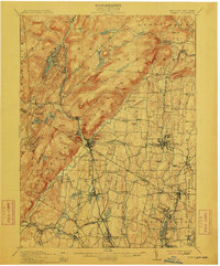
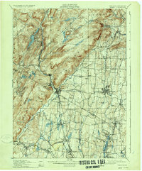
1910 Map of Ramapo
USGS Topo · Published 1912About this map
The Ramapo Mountains dominate the western half of this 1910 survey, creating a dramatic physical divide between the rugged uplands and the developing valley settlements to the east. The Ramapo River cuts a vital corridor through the hills, followed closely by the Erie Railroad as it services communities like Sloatsburg, Ramapo, and Suffern. This intersection of rail and river geography defined the industrial and residential patterns of the era, seen clearly in the concentration of housing and infrastructure near the boundary line of New York and New Jersey.
Find a feature on this map
104 named features on this map. Tap any name to fly to it.
Don’t see what you’re looking for? This feature index may not catch every label — zoom into the map to look around manually.
Map Details
Editions of this 1910 Ramapo Map
6 editions found

Other maps of this area

1888 · Morristown
USGS Topo · 1:62,500

1888 · Paterson
USGS Topo · 1:62,500

1891 · Greenwood Lake
USGS Topo · 1:62,500

1891 · Ramapo
USGS Topo · 1:62,500

1891 · Harlem
USGS Topo · 1:62,500

1892 · West Point
USGS Topo · 1:62,500

1892 · Paterson
USGS Topo · 1:62,500

1892 · Tarrytown
USGS Topo · 1:62,500

1893 · Greenwood Lake
USGS Topo · 1:62,500

1893 · Tarrytown
USGS Topo · 1:62,500