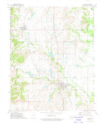
1972 Map of Ramona
USGS Topo · Published 1974About this map
Ochelata and Ramona anchor this survey of Washington County, showing the region's established reliance on the Atchison Topeka and Santa Fe railroad corridor. The landscape is a complex network of industrial activity, with numerous Oil Wells, Gas Wells, and Drill Holes scattered across the terrain, reflecting the area's mid-century energy production. Water management is central to the local infrastructure, evidenced by the Sewage Disposal Ponds and the reservoir at Lake Todd.
Find a feature on this map
26 named features on this map. Tap any name to fly to it.
Don’t see what you’re looking for? This feature index may not catch every label — zoom into the map to look around manually.
Map Details
Editions of this 1972 Ramona Map
2 editions found
Other maps of this area

1901 · Claremore
USGS Topo · 1:125,000

1901 · Nowata
USGS Topo · 1:125,000

1909 · Pawhuska
USGS Topo · 1:125,000

1910 · Pawhuska
USGS Topo · 1:125,000

1912 · Hominy
USGS Topo · 1:125,000

1914 · Nowata
USGS Topo · 1:125,000

1914 · Claremore
USGS Topo · 1:125,000

1915 · Hominy
USGS Topo · 1:125,000

1916 · Claremore
USGS Topo · 1:125,000

1954 · Tulsa
USGS Topo · 1:250,000