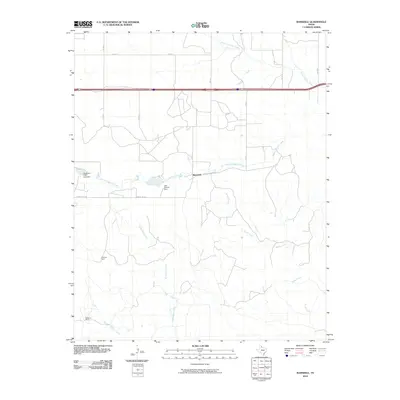
2010 Map of Ramsdell
USGS Topo · Published 2010About this map
Ramsdell and the surrounding rangeland of Wheeler County are documented in this 2010 survey, showcasing a landscape defined by ranching and intermittent drainage systems. The small community of Ramsdell sits along Co Rd South Dakota, centered near the crossing of South Long Dry Creek. This arid environment is further shaped by small-scale water management, evidenced by Lake Loraine Dam and the Sandspur Club Lake Dam situated to the west. Named family holdings like Coleman Ranch and McMurtry Ranch occupy the southern half of the quadrangle, where the terrain is dissected by the headwaters of Richardson Creek and Sandy Creek. The map provides a clear look at the rural road grid, including County Line Rd and FM 453, which connect these isolated homesteads to the wider Panhandle region.
Find a feature on this map
19 named features on this map. Tap any name to fly to it.
Don’t see what you’re looking for? This feature index may not catch every label — zoom into the map to look around manually.
Map Details
Editions of this 2010 Ramsdell Map
This is the sole edition of this map. No revisions or reprints were ever made.
Other maps of this area

1954 · Amarillo
USGS Topo · 1:250,000

1958 · Amarillo
USGS Topo · 1:250,000

1959 · Spencer Lake
USGS Topo · 1:24,000

1962 · Back
USGS Topo · 1:24,000

1962 · Wheeler SE
USGS Topo · 1:24,000

1962 · Pakan
USGS Topo · 1:24,000

1963 · Ramsdell
USGS Topo · 1:24,000

1963 · Shamrock West
USGS Topo · 1:24,000

1963 · McLean
USGS Topo · 1:24,000
1964 · Abra
USGS Topo · 1:24,000