
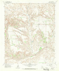
1963 Map of Ramsdell
USGS Topo · Published 1967About this map
Ramsdell sits at the intersection of rail and road infrastructure in the eastern Texas Panhandle during the early 1960s. The settlement is centered along the Chicago Rock Island and Pacific railroad, which parallels the dual routes of Highway 40 and Highway 66. This corridor represents a significant transportation artery, contrasting with the ranching landscape that defines the surrounding area. To the south, the terrain becomes increasingly dissected by drainage networks, including Richardson Creek and Sandy Creek, while the Wheeler Co Collingsworth Co boundary line divides the northern plains from the southern breaks.
Find a feature on this map
17 named features on this map. Tap any name to fly to it.
Don’t see what you’re looking for? This feature index may not catch every label — zoom into the map to look around manually.
Map Details
Editions of this 1963 Ramsdell Map
This is the sole edition of this map. No revisions or reprints were ever made.
Other maps of this area

1954 · Amarillo
USGS Topo · 1:250,000

1958 · Amarillo
USGS Topo · 1:250,000

1959 · Spencer Lake
USGS Topo · 1:24,000

1962 · Back
USGS Topo · 1:24,000

1962 · Wheeler SE
USGS Topo · 1:24,000

1962 · Pakan
USGS Topo · 1:24,000

1963 · Shamrock West
USGS Topo · 1:24,000

1963 · McLean
USGS Topo · 1:24,000
1964 · Abra
USGS Topo · 1:24,000
1964 · Dozier
USGS Topo · 1:24,000