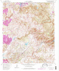
1968 Map of Rancho Santa Fe
USGS Topo · Published 1983About this map
Rancho Santa Fe serves as the focal point of this late-1960s coastal canyon landscape, as documented by the United States Geological Survey and updated in the early 1980s. The terrain is defined by its deep drainages and prominent summits, including Double Peak and Mt Whitney, which overlook a network of emerging residential communities and agricultural land. To the west, the settlement of Olivenhain sits near the Olivenhain Cemetery, while the northern reaches show the waters of Lake San Marcos and San Marcos Creek. The map documents a period of significant development as older ranch lands like Rancho de los Quiotes and Osuña meet modern infrastructure. Water management is a primary theme of the geography here, with the San Dieguito River flowing through the San Dieguito Valley and the San Dieguito Reservoir providing a central landmark for local residents and land developers during this era of growth.
Find a feature on this map
35 named features on this map. Tap any name to fly to it.
Don’t see what you’re looking for? This feature index may not catch every label — zoom into the map to look around manually.
Map Details
Editions of this 1968 Rancho Santa Fe Map
4 editions found
Other maps of this area

1893 · Oceanside
USGS Topo · 1:62,500

1893 · Escondido
USGS Topo · 1:62,500

1898 · Oceanside
USGS Topo · 1:62,500

1901 · Escondido
USGS Topo · 1:62,500

1901 · Oceanside
USGS Topo · 1:62,500

1901 · San Luis Rey
USGS Topo · 1:125,000

1903 · La Jolla
USGS Topo · 1:62,500

1904 · Southern California Sheet No. 2
USGS Topo · 1:250,000

1930 · La Jolla
USGS Topo · 1:62,500

1942 · Poway Valley
USGS Topo · 1:31,680