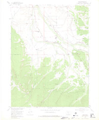
1956 Map of Rand
USGS Topo · Published 1975About this map
Rand serves as the central hub of this North Park landscape, where the Illinois River meanders through a valley defined by an extensive network of irrigation infrastructure. This mid-century survey illustrates the vital role of water management in Colorado's high-country ranching economy, documenting numerous named ditches such as Illinois Ditch, Willow Ditch, and Stevenson Ditch that feed local holdings. Family legacies are etched into the terrain through sites like Howard Ranch, Fuqua Ranch, and the Stephens Brothers Ranch. The small settlement of Rand is anchored by the Rand Sch and the Rand Cem, while the southern reaches of the quadrangle transition into the timbered slopes of Green Ridge within the Routt National Forest. Researchers can find evidence of early habitation at the Old Homestead and trace the seasonal flow of high-altitude waterways like Badgero Creek and Mc Kinnon Creek.
Find a feature on this map
53 named features on this map. Tap any name to fly to it.
Don’t see what you’re looking for? This feature index may not catch every label — zoom into the map to look around manually.
Map Details
Editions of this 1956 Rand Map
4 editions found

Other maps of this area

1954 · Craig
USGS Topo · 1:250,000

1955 · Gould
USGS Topo · 1:24,000

1955 · Owl Ridge
USGS Topo · 1:24,000

1955 · Mac Farlane Reservoir
USGS Topo · 1:24,000

1955 · Walden
USGS Topo · 1:62,500

1956 · Radial Mountain
USGS Topo · 1:24,000

1956 · Jack Creek Ranch
USGS Topo · 1:24,000

1956 · Parkview Mountain
USGS Topo · 1:24,000

1956 · Buffalo Peak
USGS Topo · 1:24,000

1956 · Hyannis Peak
USGS Topo · 1:24,000