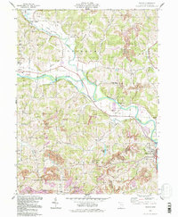
1994 Map of Randle
USGS Topo · Published 1998About this map
The Walhonding River and Killbuck Creek converge in this pocket of Coshocton County, shaping a landscape defined by its waterways and early transport routes. An Old Railroad Grade follows the northern riverbank, passing through Metham and Randle, while the Sixmile Dam and Gaging Sta indicate the managed flow of these vital basins. The influence of the Ohio and Erie Canal is visible at Roscoe Basin near the confluence with the Tuscarawas River.
Find a feature on this map
40 named features on this map. Tap any name to fly to it.
Don’t see what you’re looking for? This feature index may not catch every label — zoom into the map to look around manually.
Map Details
Editions of this 1994 Randle Map
This is the sole edition of this map. No revisions or reprints were ever made.
Other maps of this area

1908 · Conesville
USGS Topo · 1:62,500

1910 · Frazeysburg
USGS Topo · 1:62,500

1910 · Conesville
USGS Topo · 1:62,500

1913 · Brinkhaven
USGS Topo · 1:62,500

1913 · Coshocton
USGS Topo · 1:62,500

1915 · Brinkhaven
USGS Topo · 1:62,500

1915 · Coshocton
USGS Topo · 1:62,500

1943 · Coshocton
USGS Topo · 1:62,500

1950 · Marion
USGS Topo · 1:250,000

1951 · Canton
USGS Topo · 1:250,000