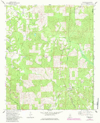
1971 Map of Randolph
USGS Topo · Published 1985About this map
The Southern railroad corridor and the Bibb Co Chilton Co boundary define the landscape of this Central Alabama region in the early 1970s. At the heart of the area is Randolph, a settlement marked by its proximity to the rail line and a prominent Radio Tower. To the northwest, the small community of Maud sits near the winding Oakmulgee Creek, while the northeastern corner is anchored by Oakley. The map reflects a rural society structured around local landmarks like the Howison Sch and a network of country churches, including Mills Ch, Antioch Ch, and Shady Grove Ch.
Find a feature on this map
22 named features on this map. Tap any name to fly to it.
Don’t see what you’re looking for? This feature index may not catch every label — zoom into the map to look around manually.
Map Details
Editions of this 1971 Randolph Map
2 editions found
Other maps of this area

1890 · Bessemer
USGS Topo · 1:125,000

1891 · Clanton
USGS Topo · 1:125,000

1892 · Bessemer
USGS Topo · 1:125,000

1899 · Brookwood
USGS Topo · 1:125,000

1910 · Montevallo
USGS Topo · 1:62,500

1934 · Blocton
USGS Topo · 1:48,000

1940 · Blocton
USGS Topo · 1:62,500

1953 · Montgomery
USGS Topo · 1:250,000

1953 · Birmingham
USGS Topo · 1:250,000

1956 · Birmingham
USGS Topo · 1:250,000