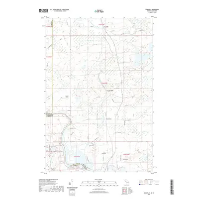
2019 Map of Randville
USGS Topo · Published 2019About this map
The Menominee River serves as the prominent natural boundary between Michigan and Wisconsin, winding through the southwest corner of this landscape. The terrain is defined by a dense network of water bodies, including Spirit Lake, Browning Lake, and Bradford Lake, alongside the flow of the W Br Sturgeon River in the north. This 2019 survey documents the small settlements of Randville, Granite Bluff, and Merriman, which are interconnected by a system of rural county roads such as Co Rd 607 and Peterson Dr. Local aviation is represented by the Lilienthal Airport, situated near several residential clusters. The map illustrates a region where local geography is tied to the numerous small lakes and creeks, including Tom Kings Cr and Pine Cr, providing a detailed look at the modern land use and drainage patterns of the border country.
Find a feature on this map
71 named features on this map. Tap any name to fly to it.
Don’t see what you’re looking for? This feature index may not catch every label — zoom into the map to look around manually.
Map Details
Editions of this 2019 Randville Map
This is the sole edition of this map. No revisions or reprints were ever made.
Other maps of this area

1899 · Sagola
USGS Topo · 1:62,500

1939 · Iron Mountain
USGS Topo · 1:48,000

1941 · Iron Mountain
USGS Topo · 1:48,000

1947 · Iron Mountain
USGS Topo · 1:48,000

1947 · Lake Mary
USGS Topo · 1:24,000
1949 · Commonwealth
USGS Topo · 1:24,000

1954 · Iron Mountain
USGS Topo · 1:250,000

1954 · Escanaba
USGS Topo · 1:250,000

1955 · Norway
USGS Topo · 1:24,000

1955 · Norway
USGS Topo · 1:62,500