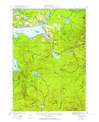
1949 Map of Rangeley
USGS Topo · Published 1964About this map
Rangeley Lake and its surrounding highland townships are meticulously detailed in this mid-century survey, documenting a landscape defined by timber, water, and early tourism. The village of Rangeley serves as the central hub, supported by smaller settlements like Dallas and Mingo Springs. The mapping shows the early footprint of the Airport and the Greenvale Sch, alongside the established path of the Appalachian Trail as it traverses the peaks of Saddleback Mtn.
Find a feature on this map
109 named features on this map. Tap any name to fly to it.
Don’t see what you’re looking for? This feature index may not catch every label — zoom into the map to look around manually.
Map Details
Editions of this 1949 Rangeley Map
4 editions found

Other maps of this area

1926 · Dixfield
USGS Topo · 1:62,500

1927 · Rumford
USGS Topo · 1:48,000

1928 · Stratton
USGS Topo · 1:48,000

1929 · Phillips
USGS Topo · 1:48,000

1929 · Dixfield
USGS Topo · 1:62,500

1930 · Rumford
USGS Topo · 1:62,500

1931 · Cupsuptic
USGS Topo · 1:48,000

1932 · Phillips
USGS Topo · 1:62,500

1932 · Stratton
USGS Topo · 1:62,500

1932 · Kennebago Lake
USGS Topo · 1:48,000
Featured Places
- Rangeley, ME
- Dallas Plantation, ME
- Rangeley Plantation, ME
- Madrid Township, ME
- Sandy River Plantation, ME