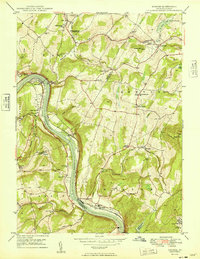
1949 Map of Ransom
USGS Topo · Published 1949About this map
The Susquehanna River carves a deep valley through the center of this 1949 survey, shaping the transport and settlement patterns of Lackawanna, Luzerne, and Wyoming Counties. The Lehigh Valley Railroad and the Sullivan Trail follow the river's tight curves, connecting riverside settlements like Ransom and West Falls. A prominent landmark in the south is the Ransom-Newton State Hospital, while the Scranton Airport sits on a plateau near Griffin Hill to the northeast.
Find a feature on this map
58 named features on this map. Tap any name to fly to it.
Don’t see what you’re looking for? This feature index may not catch every label — zoom into the map to look around manually.
Map Details
Editions of this 1949 Ransom Map
This is the sole edition of this map. No revisions or reprints were ever made.
Other maps of this area

1889 · Scranton
USGS Topo · 1:62,500

1891 · Scranton
USGS Topo · 1:62,500

1892 · Dundaff
USGS Topo · 1:62,500

1893 · Pittston
USGS Topo · 1:62,500

1893 · Scranton
USGS Topo · 1:62,500

1943 · Scranton
USGS Topo · 1:125,000

1946 · Tunkhannock
USGS Topo · 1:62,500

1946 · Dalton
USGS Topo · 1:24,000

1946 · Kingston
USGS Topo · 1:24,000
1946 · Avoca
USGS Topo · 1:24,000
Featured Places
- Falls Township, PA
- Glenburn Township, PA
- Ransom Township, PA
- Upper Exeter, Exeter Township
- Mill City, Falls Township