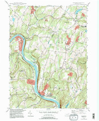
1994 Map of Ransom
USGS Topo · Published 1995About this map
The Susquehanna River carves a deep valley through the heart of this Pennsylvania landscape, serving as the historical boundary between several municipalities and counties. Settled pockets like Mill City and Ransom are connected by the historic Sullivan Trail, while the higher elevations of Griffin Hill and Bald Mtn separate the river corridor from the surrounding plateau. The map highlights the educational and spiritual centers of these rural communities, featuring the Newton-Ransom Sch and St Benedict Ch alongside family and community resting places such as the Post Hill Cem. This 1990s revision reflects a mix of traditional agriculture and modern infrastructure, shown through features like the Sewage Disp Plant near Ransom and several active Quarry and Gravel Pit operations that define the local industry and geology.
Find a feature on this map
55 named features on this map. Tap any name to fly to it.
Don’t see what you’re looking for? This feature index may not catch every label — zoom into the map to look around manually.
Map Details
Editions of this 1994 Ransom Map
This is the sole edition of this map. No revisions or reprints were ever made.
Other maps of this area

1889 · Scranton
USGS Topo · 1:62,500

1891 · Scranton
USGS Topo · 1:62,500

1892 · Dundaff
USGS Topo · 1:62,500

1893 · Pittston
USGS Topo · 1:62,500

1893 · Scranton
USGS Topo · 1:62,500

1943 · Scranton
USGS Topo · 1:125,000

1946 · Tunkhannock
USGS Topo · 1:62,500

1946 · Dalton
USGS Topo · 1:24,000

1946 · Kingston
USGS Topo · 1:24,000
1946 · Avoca
USGS Topo · 1:24,000
Featured Places
- Falls Township, PA
- Glenburn Township, PA
- Ransom Township, PA
- Upper Exeter, Exeter Township
- Mill City, Falls Township