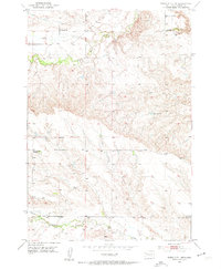
1953 Map of Rapid City 1 NW
USGS Topo · Published 1954About this map
Bear Butte Creek winds through the northern reaches of this Meade County landscape, defining a terrain shaped by the watercourses that descend toward the plains. The early 1950s settlement pattern is anchored by a network of rural schoolhouses, including Volunteer Sch, Wolff Sch, and the North Middle Alkali Sch, which served the scattered ranching and farming community. In the southern portion of the quadrangle, Alkali Creek parallels the path of the Alkali Road, a vital local artery connecting these remote homesteads. Near the Lower Alkali Sch, a Gravel Pit indicates localized resource extraction, supporting the maintenance of the unpaved road network. This survey, based on 1948 aerial photography, provides a detailed view of the section-line roads and drainages that organized life in western South Dakota before modern development altered the rural school districts.
Find a feature on this map
8 named features on this map. Tap any name to fly to it.
Don’t see what you’re looking for? This feature index may not catch every label — zoom into the map to look around manually.
Map Details
Editions of this 1953 Rapid City 1 NW Map
3 editions found

Other maps of this area

1893 · Rapid
USGS Topo · 1:125,000

1898 · Rapid
USGS Topo · 1:125,000

1903 · Rapid
USGS Topo · 1:125,000

1906 · Vale
USGS Topo · 1:62,500

1913 · Newell
USGS Topo · 1:125,000

1951 · Volunteer
USGS Topo · 1:24,000

1951 · Volunteer SE
USGS Topo · 1:24,000

1951 · Vale SE
USGS Topo · 1:24,000

1951 · Vale
USGS Topo · 1:62,500

1953 · Rapid City 1 SW
USGS Topo · 1:24,000