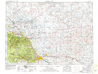
1953 Map of Rapid City
USGS Topo · Published 1978About this map
The rugged gateway to the Black Hills National Forest unfolds in this 1950s-era revision, centered on the expansion of Rapid City and the strategic positioning of Ellsworth Air Force Base. To the west, the landscape transitions from the high plains into the iconic peaks of the Black Hills, featuring landmarks like Bear Butte State Park and Crook Mountain. The map provides a detailed view of the regional infrastructure including the Chicago and North Western rail lines and significant water management at the Belle Fourche Reservoir and Pactola Reservoir. Smaller outposts such as Deadwood, Lead, and Spearfish anchor the mountain valleys, while the Fort Meade Veterans Administration Hospital stands near Sturgis. This survey captures the post-war development of western South Dakota as military presence and land management agencies established permanent footprints on the frontier.
Find a feature on this map
89 named features on this map. Tap any name to fly to it.
Don’t see what you’re looking for? This feature index may not catch every label — zoom into the map to look around manually.
Map Details
Editions of this 1953 Rapid City Map
3 editions found

Other maps of this area

1893 · Rapid
USGS Topo · 1:125,000

1894 · Deadwood
USGS Topo · 1:125,000

1894 · Hermosa
USGS Topo · 1:125,000

1896 · Harney Peak
USGS Topo · 1:125,000

1898 · Sundance
USGS Topo · 1:125,000

1898 · Rapid
USGS Topo · 1:125,000

1899 · Sturgis
USGS Topo · 1:62,500

1899 · Newcastle
USGS Topo · 1:125,000

1900 · Spearfish
USGS Topo · 1:62,500

1901 · Hermosa
USGS Topo · 1:125,000