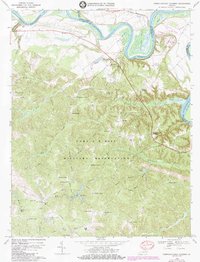
1969 Map of Rappahannock Academy
USGS Topo · Published 1984About this map
The Rappahannock River creates dramatic loops through the northern landscape of this Virginia survey, defining the fertile peninsulas of Moss Neck, Corbins Neck, and Skinkers Neck. This river-oriented economy is reflected in historical transport points like Hayfield Wharf and Moons Mount Wharf, which once served as vital links for moving goods along the waterway. Further south, the map is dominated by the Fort AP Hill Military Reservation, a vast expanse of terrain crossed by named trails and roads such as Overland Trail and Burma Road.
Find a feature on this map
78 named features on this map. Tap any name to fly to it.
Don’t see what you’re looking for? This feature index may not catch every label — zoom into the map to look around manually.
Map Details
Editions of this 1969 Rappahannock Academy Map
3 editions found
Other maps of this area

1889 · Fredericksburg
USGS Topo · 1:125,000

1892 · Fredericksburg
USGS Topo · 1:125,000

1894 · Fredericksburg
USGS Topo · 1:125,000

1926 · Stafford
USGS Topo · 1:62,500

1931 · Stafford
USGS Topo · 1:62,500

1942 · Bowling Green
USGS Topo · 1:31,680

1942 · Upper Zion
USGS Topo · 1:31,680

1942 · Woodford
USGS Topo · 1:31,680

1942 · Guinea
USGS Topo · 1:31,680

1942 · Port Royal
USGS Topo · 1:31,680