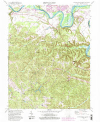
1994 Map of Rappahannock Academy
USGS Topo · Published 2000About this map
The Fort A P Hill Military Reservation dominates the lower two-thirds of this landscape, its boundary lines crisscrossed by old forest trails and named thoroughfares such as Burma Road and Windsor Road. This military presence preserved a large swathe of rural Caroline County from modern residential development, keeping historical landmarks like Bethesda Church and Travis Mill within its secure perimeter. To the north, the Rappahannock River meanders through fertile lowlands, defining several prominent bends including Moss Neck and Corbins Neck.
Find a feature on this map
65 named features on this map. Tap any name to fly to it.
Don’t see what you’re looking for? This feature index may not catch every label — zoom into the map to look around manually.
Map Details
Editions of this 1994 Rappahannock Academy Map
3 editions found
Other maps of this area

1889 · Fredericksburg
USGS Topo · 1:125,000

1892 · Fredericksburg
USGS Topo · 1:125,000

1894 · Fredericksburg
USGS Topo · 1:125,000

1926 · Stafford
USGS Topo · 1:62,500

1931 · Stafford
USGS Topo · 1:62,500

1942 · Bowling Green
USGS Topo · 1:31,680

1942 · Upper Zion
USGS Topo · 1:31,680

1942 · Woodford
USGS Topo · 1:31,680

1942 · Guinea
USGS Topo · 1:31,680

1942 · Port Royal
USGS Topo · 1:31,680