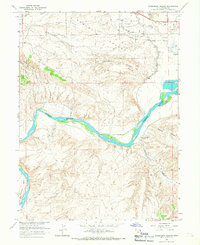
1965 Map of Rasmussen Hollow
USGS Topo · Published 1967About this map
Ashley Valley defines the northern reaches of this mid-1960s landscape, where the Green River carves a sweeping path toward the Horseshoe Bend in the southwest. The geography is marked by the industrial footprints of energy extraction and water management, notably an extensive Oil Field and numerous scattered Drill Holes. The geological prominence of Asphalt Ridge runs along the western edge, overlooking a network of drainages including Rasmussen Hollow and Ashley Creek.
Find a feature on this map
21 named features on this map. Tap any name to fly to it.
Don’t see what you’re looking for? This feature index may not catch every label — zoom into the map to look around manually.
Map Details
Editions of this 1965 Rasmussen Hollow Map
2 editions found
Other maps of this area

1885 · Ashley
USGS Topo · 1:250,000

1907 · Jensen
USGS Topo · 1:125,000

1910 · Jensen
USGS Topo · 1:125,000

1917 · Vernal
USGS Topo · 1:125,000

1954 · Vernal
USGS Topo · 1:250,000

1958 · Vernal
USGS Topo · 1:250,000

1960 · Vernal
USGS Topo · 1:250,000

1964 · Vernal NE
USGS Topo · 1:24,000

1964 · Brennan Basin
USGS Topo · 1:24,000
1964 · Vernal SE
USGS Topo · 1:24,000