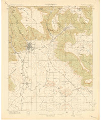
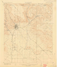
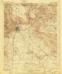
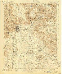
1914 Map of Raton
USGS Topo · Published 1914About this map
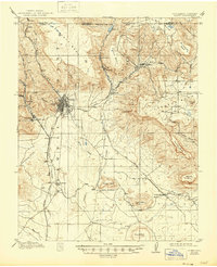
The high mesa country of the New Mexico-Colorado border is dominated here by the transport gateway of Raton, a critical railroad and wagon hub in the early 20th century. The Atchison Topeka and Santa Fe Railroad navigates the challenging terrain through the Raton Tunnel, connecting the high plains to the settlements of Wootton and Lynn. Coal mining and early industrial footprints are visible in the clusters at Blossburg, Gardiner, and the Wagon Mine, while the Raton and Eastern RR pushes into the foothills toward Yankee. This landscape is a patchwork of massive uplifted plateaus, including Bartlett Mesa and Johnson Mesa, where the headwaters of the Canadian River and Sugarite Creek begin their descent. Historical markers like the Clifton House reflect the area's legacy as a stop on the Santa Fe Road.
Find a feature on this map
51 named features on this map. Tap any name to fly to it.
Don’t see what you’re looking for? This feature index may not catch every label — zoom into the map to look around manually.
Map Details
Editions of this 1914 Raton Map
5 editions found
Other maps of this area

1891 · Spanish Peaks
USGS Topo · 1:125,000

1892 · Elmoro
USGS Topo · 1:125,000

1893 · Spanish Peaks
USGS Topo · 1:125,000

1893 · Elmoro
USGS Topo · 1:125,000

1895 · Spanish Peaks
USGS Topo · 1:125,000
1897 · Elmoro
USGS Topo · 1:125,000

1897 · Spanish Peaks
USGS Topo · 1:125,000

1900 · Spanish Peaks
USGS Topo · 1:125,000
1912 · Raton
USGS Topo · 1:62,500
1915 · Brilliant
USGS Topo · 1:62,500