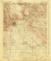
1914 Map of Raton
USGS Topo · Published 1930About this map
The high desert and mesa country of the New Mexico-Colorado borderlands are defined here by the critical rail corridors and early coal mining operations of the early 20th century. Raton sits as the central hub beneath Bartlett Mesa, where the At&SF RR pierces the landscape through the Raton Tunnel. This intersection of geography and industry is evident in the cluster of company towns and mining settlements like Blossburg, Gardiner, and Sugarite, which were essential to the region's energy economy.
Find a feature on this map
45 named features on this map. Tap any name to fly to it.
Don’t see what you’re looking for? This feature index may not catch every label — zoom into the map to look around manually.
Map Details
Editions of this 1914 Raton Map
5 editions found
Other maps of this area

1891 · Spanish Peaks
USGS Topo · 1:125,000

1892 · Elmoro
USGS Topo · 1:125,000

1893 · Spanish Peaks
USGS Topo · 1:125,000

1893 · Elmoro
USGS Topo · 1:125,000

1895 · Spanish Peaks
USGS Topo · 1:125,000

1897 · Elmoro
USGS Topo · 1:125,000

1897 · Spanish Peaks
USGS Topo · 1:125,000

1900 · Spanish Peaks
USGS Topo · 1:125,000

1912 · Raton
USGS Topo · 1:62,500

1914 · Raton
USGS Topo · 1:62,500