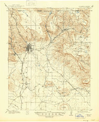
1914 Map of Raton
USGS Topo · Published 1946About this map
The high mesa country of the New Mexico-Colorado border defines this 1910s landscape, centered on the transit and mining hub of Raton. Anchored by the Atchison Topeka and Santa Fe Railroad, the region shows a dense network of early industrial infrastructure, including the critical Raton Tunnel and the Santa Fe Raton and Eastern RR. Mining operations such as the Wagon Mine and settlements like Sugarite and Blossburg are connected by rugged topography, where Bartlett Mesa and Horse Mesa dominate the skyline.
Find a feature on this map
54 named features on this map. Tap any name to fly to it.
Don’t see what you’re looking for? This feature index may not catch every label — zoom into the map to look around manually.
Map Details
Editions of this 1914 Raton Map
5 editions found
Other maps of this area

1891 · Spanish Peaks
USGS Topo · 1:125,000

1892 · Elmoro
USGS Topo · 1:125,000

1893 · Spanish Peaks
USGS Topo · 1:125,000

1893 · Elmoro
USGS Topo · 1:125,000

1895 · Spanish Peaks
USGS Topo · 1:125,000

1897 · Elmoro
USGS Topo · 1:125,000

1897 · Spanish Peaks
USGS Topo · 1:125,000

1900 · Spanish Peaks
USGS Topo · 1:125,000

1912 · Raton
USGS Topo · 1:62,500

1914 · Raton
USGS Topo · 1:62,500