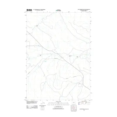
2012 Map of Rattlesnake Gulch
USGS Topo · Published 2012About this map
Owl Cr and Mud Cr define the drainage patterns of this high desert landscape in Hot Springs County. The territory is characterized by a network of seasonal watercourses and draws, including Spring Draw, Alkali Draw, and Eagle Draw, which feed into the larger creek systems. Water management for local ranching or agricultural needs is evidenced by the presence of Rush Reservoir, a vital point of collection in an otherwise arid environment.
Find a feature on this map
13 named features on this map. Tap any name to fly to it.
Don’t see what you’re looking for? This feature index may not catch every label — zoom into the map to look around manually.
Map Details
Editions of this 2012 Rattlesnake Gulch Map
This is the sole edition of this map. No revisions or reprints were ever made.
Other maps of this area

1914 · Blue Mesa
USGS Topo · 1:62,500

1916 · Blue Mesa
USGS Topo · 1:62,500

1945 · Kirby
USGS Topo · 1:62,500

1946 · Kirby
USGS Topo · 1:62,500

1955 · Thermopolis
USGS Topo · 1:250,000

1958 · Thermopolis
USGS Topo · 1:250,000
1960 · Wedding Of The Waters
USGS Topo · 1:24,000

1960 · Thermopolis
USGS Topo · 1:24,000

1962 · Thermopolis
USGS Topo · 1:250,000
1965 · Potato Butte
USGS Topo · 1:24,000