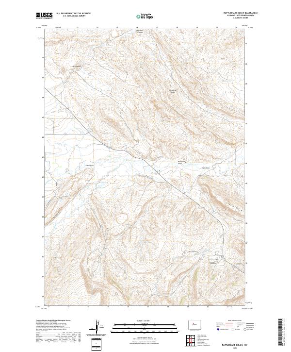
2021 Map of Rattlesnake Gulch
USGS Topo · Published 2021About this map
Cedar Ridge and the winding drainage of Owl Cr define the high plains character of this Hot Springs County landscape. The area is marked by a complex network of ephemeral watercourses including Rattlesnake Gulch, Eagle Draw, and South Fork Coal Draw, illustrating the erosional patterns of the Wyoming basin. Modern infrastructure is limited to rural thoroughfares like Missouri Flat Rd and Red Canyon Rd, which navigate the varying elevations between Meeteetse Draw and Alkali Draw. The presence of the Rush Reservoir in the western portion of the map provides a rare permanent water feature in an otherwise arid drainage system. This 2021 survey details the intersections of historic township boundaries and the modern road network, including residential traces along Georgia St and Nostrum St near the southern map edge.
Find a feature on this map
28 named features on this map. Tap any name to fly to it.
Don’t see what you’re looking for? This feature index may not catch every label — zoom into the map to look around manually.
Map Details
Editions of this 2021 Rattlesnake Gulch Map
This is the sole edition of this map. No revisions or reprints were ever made.
Other maps of this area

1914 · Blue Mesa
USGS Topo · 1:62,500

1916 · Blue Mesa
USGS Topo · 1:62,500

1945 · Kirby
USGS Topo · 1:62,500

1946 · Kirby
USGS Topo · 1:62,500

1955 · Thermopolis
USGS Topo · 1:250,000

1958 · Thermopolis
USGS Topo · 1:250,000
1960 · Wedding Of The Waters
USGS Topo · 1:24,000

1960 · Thermopolis
USGS Topo · 1:24,000

1962 · Thermopolis
USGS Topo · 1:250,000
1965 · Potato Butte
USGS Topo · 1:24,000