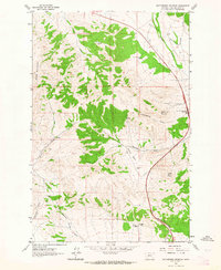
1962 Map of Rattlesnake Mountain
USGS Topo · Published 1964About this map
High peaks and named basins define this section of the Big Belt Mountains in the early 1960s. Baldy Mountain and Rattlesnake Mountain overlook a complex network of gulches and valleys, including the prominent Hilger Valley and McLeod Basin. The landscape is marked by isolated outposts of human activity, such as Payne Camp and the Old Synnes Ranch, suggesting a legacy of high-country ranching and seasonal habitation.
Find a feature on this map
25 named features on this map. Tap any name to fly to it.
Don’t see what you’re looking for? This feature index may not catch every label — zoom into the map to look around manually.
Map Details
Editions of this 1962 Rattlesnake Mountain Map
4 editions found
Other maps of this area

1886 · Fort Logan
USGS Topo · 1:250,000

1889 · Helena
USGS Topo · 1:250,000

1893 · Helena
USGS Topo · 1:250,000

1899 · Helena
USGS Topo · 1:62,500

1899 · Helena
USGS Topo · 1:250,000

1903 · Helena
USGS Topo · 1:250,000

1947 · Butte
USGS Topo · 1:250,000

1948 · White Sulphur Springs
USGS Topo · 1:250,000

1950 · East Helena
USGS Topo · 1:62,500

1950 · Helena
USGS Topo · 1:62,500