
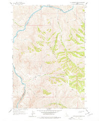
1963 Map of Rattlesnake Ridge
USGS Topo · Published 1965About this map
The Salmon River cuts through the western edge of this territory, following the boundary between Nez Perce Co and Idaho Co. This rugged landscape is dominated by the sprawling backbone of Rattlesnake Ridge, which serves as a major drainage divide for several seasonal and perennial waterways. The map documents an area defined by its isolation and steep drainages, where human presence is sparse and limited to specific cattle or sheep ranching operations.
Find a feature on this map
28 named features on this map. Tap any name to fly to it.
Don’t see what you’re looking for? This feature index may not catch every label — zoom into the map to look around manually.
Map Details
Editions of this 1963 Rattlesnake Ridge Map
2 editions found
Other maps of this area

1946 · Limekiln Rapids
USGS Topo · 1:62,500

1955 · Pullman
USGS Topo · 1:250,000

1955 · Grangeville
USGS Topo · 1:250,000

1958 · Pullman
USGS Topo · 1:250,000

1959 · Grangeville
USGS Topo · 1:250,000

1963 · Cactus Mtn
USGS Topo · 1:24,000

1963 · Deadhorse Ridge
USGS Topo · 1:24,000

1963 · Boles
USGS Topo · 1:24,000

1963 · Wapshilla Creek
USGS Topo · 1:24,000

1963 · Wolf Creek
USGS Topo · 1:24,000