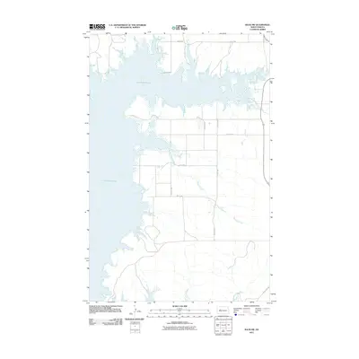
2011 Map of Raub NW
USGS Topo · Published 2011About this map
Lake Sakakawea dominates the western and northern portions of this landscape, its complex shoreline defining the boundary between the water and the upland plateaus of North Dakota. The interior of the quadrangle is etched by the meandering course of Charging Creek, which drains toward the reservoir through a network of coulees. The landscape is organized by a precise grid of rural section-line roads, such as 23rd St NW and 75th Ave NW, which speak to the area’s agricultural heritage and the systematic division of the land following the homesteading era. This survey, compiled in 2011, records the specific configuration of the shoreline and the persistent rural infrastructure surrounding Parshall prior to any subsequent changes in the water level or local development.
Find a feature on this map
10 named features on this map. Tap any name to fly to it.
Don’t see what you’re looking for? This feature index may not catch every label — zoom into the map to look around manually.
Map Details
Editions of this 2011 Raub NW Map
This is the sole edition of this map. No revisions or reprints were ever made.
Other maps of this area

1953 · Watford City
USGS Topo · 1:250,000

1957 · Watford City
USGS Topo · 1:250,000

1967 · Watford City
USGS Topo · 1:250,000

1967 · Raub SE
USGS Topo · 1:24,000

1967 · Raub NW
USGS Topo · 1:24,000

1967 · Raub
USGS Topo · 1:24,000

1967 · Twin Buttes
USGS Topo · 1:24,000
1967 · Parshall SE
USGS Topo · 1:24,000

1967 · Parshall SW
USGS Topo · 1:24,000

1967 · New Town SE
USGS Topo · 1:24,000