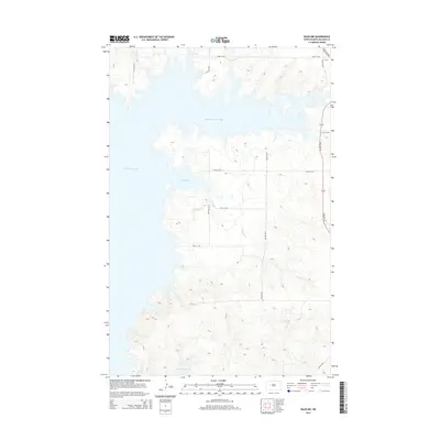
2014 Map of Raub NW
USGS Topo · Published 2014About this map
Lake Sakakawea dominates the western landscape of this McLean County region, where the Missouri River reservoir creates a complex shoreline of protected inlets. The map details the indented coastlines of Deepwater Creek Bay in the north and Arikara Bay further south, illustrating the dramatic interaction between the high plains and the flooded river valley. Drainage from the eastern uplands is channeled through Charging Cr, which meanders toward the reservoir through the prairie breaks. The upland terrain is structured by a strictly rectilinear grid of local roads, such as 23rd St NW and 72nd Ave NW, which provide access to the agricultural parcels overlooking the water. This 2014 survey captures a landscape defined by the intersection of mid-century water management projects and the enduring Section Line road system of the northern plains.
Find a feature on this map
16 named features on this map. Tap any name to fly to it.
Don’t see what you’re looking for? This feature index may not catch every label — zoom into the map to look around manually.
Map Details
Editions of this 2014 Raub NW Map
This is the sole edition of this map. No revisions or reprints were ever made.
Other maps of this area

1953 · Watford City
USGS Topo · 1:250,000

1957 · Watford City
USGS Topo · 1:250,000

1967 · Watford City
USGS Topo · 1:250,000

1967 · Raub SE
USGS Topo · 1:24,000

1967 · Raub NW
USGS Topo · 1:24,000

1967 · Raub
USGS Topo · 1:24,000

1967 · Twin Buttes
USGS Topo · 1:24,000
1967 · Parshall SE
USGS Topo · 1:24,000

1967 · Parshall SW
USGS Topo · 1:24,000

1967 · New Town SE
USGS Topo · 1:24,000