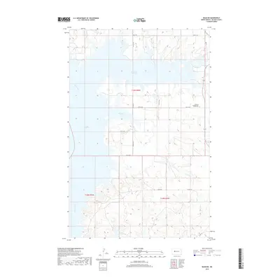
2018 Map of Raub NW
USGS Topo · Published 2018About this map
Lake Sakakawea and the winding course of the Missouri River define this North Dakota landscape, where the Garrison Dam's waters reached far into the prairie drainage systems. The map captures the complex shoreline formed by these flooded valleys, most notably at Deepwater Creek Bay and Arikara Bay. Local history and genealogy interests center on the Memorial Congregational Church Cem located near the eastern boundary, a quiet landmark amidst the township and range survey lines of t149n r90w and t148n r90w. The terrain is marked by the seasonal flow of Charging Cr and a network of Bureau of Indian Affairs and county roads, including Bia Rd 904 and Hwy 37, which navigate the high ground above the reservoir.
Find a feature on this map
18 named features on this map. Tap any name to fly to it.
Don’t see what you’re looking for? This feature index may not catch every label — zoom into the map to look around manually.
Map Details
Editions of this 2018 Raub NW Map
This is the sole edition of this map. No revisions or reprints were ever made.
Other maps of this area

1953 · Watford City
USGS Topo · 1:250,000

1957 · Watford City
USGS Topo · 1:250,000

1967 · Watford City
USGS Topo · 1:250,000

1967 · Raub SE
USGS Topo · 1:24,000

1967 · Raub NW
USGS Topo · 1:24,000

1967 · Raub
USGS Topo · 1:24,000

1967 · Twin Buttes
USGS Topo · 1:24,000
1967 · Parshall SE
USGS Topo · 1:24,000

1967 · Parshall SW
USGS Topo · 1:24,000

1967 · New Town SE
USGS Topo · 1:24,000