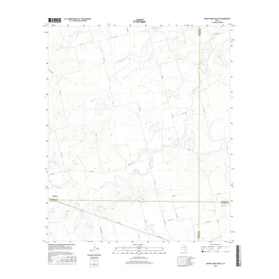
2016 Map of Raven Creek South
USGS Topo · Published 2016About this map
Eskota sits at the southwestern edge of this landscape, marking a meeting point of several West Texas counties. The map documents a sparsely populated ranching region where the boundaries of Fisher, Nolan, Jones, and Taylor counties converge. Water is the defining feature of the topography, with a complex network of ephemeral drainages such as Raven Creek, the South Fork, and Dry Cr cutting through the terrain. To the south, the curiously named Stink Cr and its tributary Little Stink Cr wind through the hills, followed closely by Stink Creek Rd. The road network is primarily composed of county routes and farm-to-market roads like FM 1085, which facilitate travel between the scattered homesteads and the nearby county lines. This survey captures the rural character of the area where the rolling plains begin to transition into the more broken country of the southern Rolling Plains.
Find a feature on this map
34 named features on this map. Tap any name to fly to it.
Don’t see what you’re looking for? This feature index may not catch every label — zoom into the map to look around manually.
Map Details
Editions of this 2016 Raven Creek South Map
This is the sole edition of this map. No revisions or reprints were ever made.
Other maps of this area

1893 · Roby
USGS Topo · 1:125,000

1893 · Sweetwater
USGS Topo · 1:125,000

1954 · Big Spring
USGS Topo · 1:250,000

1957 · Merkel
USGS Topo · 1:62,500

1957 · Noodle
USGS Topo · 1:62,500

1958 · Big Spring
USGS Topo · 1:250,000

1969 · Eskota
USGS Topo · 1:24,000
1969 · Longworth
USGS Topo · 1:24,000
1969 · Lake Sweetwater
USGS Topo · 1:24,000
1984 · Noodle NE
USGS Topo · 1:24,000