
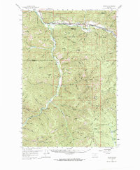
1959 Map of Ravenna
USGS Topo · Published 1961About this map
Chicago Milwaukee St Paul and Pacific and Northern Pacific railroads define the northern corridor of this landscape, following the course of the Clark Fork river. In the late 1950s, this area serves as a rugged intersection of industrial transport and vast timberlands, spanning the Missoula and Granite County line. Small settlements such as Ravenna and Nimrod sit along the rails, while the interior is dominated by the Lolo National Forest and Deerlodge National Forest. To the south, the deep valley of Rock Creek carves through the mountains, providing a lifeline for remote sites like Quigley. Local peaks and ridges, including Babcock Mountain and Solomon Mtn, overlook a network of gulches and pack trails that reveal the area's history of logging and prospecting, evidenced by several Mine and Prospect labels scattered near Brewster Creek.
Find a feature on this map
59 named features on this map. Tap any name to fly to it.
Don’t see what you’re looking for? This feature index may not catch every label — zoom into the map to look around manually.
Map Details
Editions of this 1959 Ravenna Map
2 editions found
Other maps of this area

1903 · Bonner
USGS Topo · 1:125,000

1908 · Philipsburg
USGS Topo · 1:125,000

1909 · Sapphire
USGS Topo · 1:125,000

1919 · Drummond
USGS Topo · 1:125,000

1921 · Drummond
USGS Topo · 1:125,000

1947 · Butte
USGS Topo · 1:250,000

1958 · Butte
USGS Topo · 1:250,000

1959 · Cleveland Mountain
USGS Topo · 1:62,500

1959 · Bearmouth
USGS Topo · 1:62,500

1960 · Butte
USGS Topo · 1:250,000