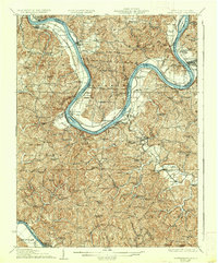
1928 Map of Ravenswood
USGS Topo · Published 1937About this map
The Ohio River dominates this landscape, carving a dramatic path through the borderlands of West Virginia and Ohio. This survey captures a dense network of early 20th-century rural infrastructure, where the Baltimore and Ohio RR tracks follow the river's edge, passing through Ravenswood and Graham Station. The interior is defined by a high concentration of community landmarks, including dozens of named schools like Walnut Grove School and Silver Valley School, and numerous country churches such as Union Church and Shiloh Church. The river navigation system is clearly marked with Lock No 24 and Lock No 23, alongside distinctive river features like the Great Bend and Buffington I. The map reveals a highly settled agricultural region before modern consolidations, where small hubs like Cottageville, Evans, and Letart Falls served as central points for the surrounding hollows and ridges.
Find a feature on this map
125 named features on this map. Tap any name to fly to it.
Don’t see what you’re looking for? This feature index may not catch every label — zoom into the map to look around manually.
Map Details
Editions of this 1928 Ravenswood Map
3 editions found

Other maps of this area

1906 · Belleville
USGS Topo · 1:62,500

1906 · Glenwood
USGS Topo · 1:62,500

1906 · Kenna
USGS Topo · 1:62,500

1906 · Winfield
USGS Topo · 1:62,500

1907 · Kenna
USGS Topo · 1:62,500

1907 · Pomeroy
USGS Topo · 1:62,500

1907 · Keno
USGS Topo · 1:62,500

1907 · Ripley
USGS Topo · 1:62,500

1908 · Glenwood
USGS Topo · 1:62,500

1908 · Winfield
USGS Topo · 1:62,500