
1964 Map of Ravinia
USGS Topo · Published 1965About this map
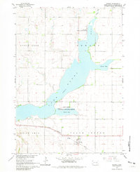
Lake Andes dominates this 1964 landscape, its distinctive shape stretching across the Charles Mix County terrain toward the settlement of Ravinia. The map documents a critical conservation era with the Lake Andes National Wildlife Refuge protecting the shoreline and marshy reaches of Johnson Bay and Owens Bay. A clear transportation corridor is visible to the south, where the Chicago Milwaukee St Paul and Pacific railroad tracks run parallel to the southern edge of the lake.
Find a feature on this map
13 named features on this map. Tap any name to fly to it.
Don’t see what you’re looking for? This feature index may not catch every label — zoom into the map to look around manually.
Map Details
Editions of this 1964 Ravinia Map
2 editions found
Other maps of this area

1955 · Mitchell
USGS Topo · 1:250,000

1959 · Mitchell
USGS Topo · 1:250,000

1964 · Wagner NE
USGS Topo · 1:24,000

1964 · Fort Randall Dam
USGS Topo · 1:24,000

1964 · Lake Andes
USGS Topo · 1:24,000

1964 · Wagner
USGS Topo · 1:24,000

1964 · Wagner SW
USGS Topo · 1:24,000
1977 · Wagner
USGS Topo · 1:24,000
1977 · Wagner SW
USGS Topo · 1:24,000
1977 · Wagner NE
USGS Topo · 1:24,000
Featured Places
- Ravinia, SD
- Howard Township, SD
- Lake View Hutterite Colony, SD
- Goose Lake Township, SD
- White Swan Township, SD