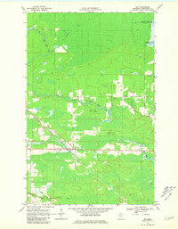
1969 Map of Ray
USGS Topo · Published 1981About this map
Ray serves as the primary hub on this northern Minnesota landscape, situated where the Duluth Winnipeg and Pacific railroad cuts through the dense woodlands of the Kabetogama State Forest. This 1969 field-checked survey reveals a territory defined by its complex hydrology, with the meandering Rat Root River and its East Branch dominating the terrain alongside Tom Cod Creek. The northeast corner of the map captures a portion of Kabetogama Lake, while the interior is marked by numerous winter trails and a jeep trail, indicating the seasonal nature of transportation in these wetlands. Local history is anchored by the Ray Cem and Lyman Cem, providing important landmarks for genealogical research in this sparsely populated region of Koochiching County.
Find a feature on this map
15 named features on this map. Tap any name to fly to it.
Don’t see what you’re looking for? This feature index may not catch every label — zoom into the map to look around manually.
Map Details
Editions of this 1969 Ray Map
4 editions found
Other maps of this area

1919 · International Falls
USGS Topo · 1:62,500

1954 · International Falls
USGS Topo · 1:250,000

1957 · International Falls
USGS Topo · 1:250,000

1958 · International Falls
USGS Topo · 1:250,000

1963 · Ranier
USGS Topo · 1:24,000

1969 · Ray SE
USGS Topo · 1:24,000

1969 · Island View
USGS Topo · 1:24,000

1969 · Ericsburg
USGS Topo · 1:24,000

1969 · Ericsburg SE
USGS Topo · 1:24,000

1969 · Ray
USGS Topo · 1:24,000