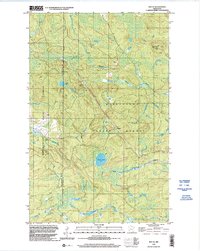
1999 Map of Ray SE
USGS Topo · Published 2003About this map
Kabetogama State Forest dominates this landscape, providing a snapshot of the Northwoods before the turn of the millennium. The terrain is defined by the winding course of the Rat Root River and its East Branch, which carve through the dense timberland alongside smaller drainages like Kinmount Creek. Evidence of forestry and communication infrastructure is visible at high points, notably the Kabetogama Lookout Tower and an adjacent Radio Tower near the eastern boundary.
Find a feature on this map
13 named features on this map. Tap any name to fly to it.
Don’t see what you’re looking for? This feature index may not catch every label — zoom into the map to look around manually.
Map Details
Editions of this 1999 Ray SE Map
This is the sole edition of this map. No revisions or reprints were ever made.
Other maps of this area

1954 · International Falls
USGS Topo · 1:250,000

1957 · International Falls
USGS Topo · 1:250,000

1958 · International Falls
USGS Topo · 1:250,000

1968 · Daley Bay
USGS Topo · 1:24,000

1968 · Ash Lake
USGS Topo · 1:24,000

1968 · Ash River SW
USGS Topo · 1:24,000

1969 · Ray SE
USGS Topo · 1:24,000

1969 · Ray
USGS Topo · 1:24,000

1969 · Ray SW
USGS Topo · 1:24,000

1969 · Kabetogama
USGS Topo · 1:24,000