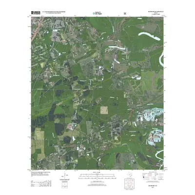
2013 Map of Rayburn
USGS Topo · Published 2013About this map
Shepherd sits at the northwestern edge of this 2013 survey, where a dense network of local roads including Lilley Rd and Ridgewood Dr gives way to the creeks and bayous of East Texas. The landscape is defined by the drainage systems of Coley Cr, Cherry Cr, and Phillips Cr, which wind toward the Trinity River in the east. Numerous small water bodies and private impoundments dot the region, notably Lake Tejas and the humorously named Lake Run-A-Muck. This modern mapping shows the expansion of residential clusters around the historic settlement nodes of Rayburn, Dolen, and Hightower. Near the Lake Water Wheel Airport, geographical markers like Cain Ridge and the Grama Grass Bottom highlight the varied alluvial terrain. Genealogical interest is anchored by features like the Coley Creek Cem and family-named roads such as Gardner Ln and Willie Mae Ln.
Find a feature on this map
167 named features on this map. Tap any name to fly to it.
Don’t see what you’re looking for? This feature index may not catch every label — zoom into the map to look around manually.
Map Details
Editions of this 2013 Rayburn Map
This is the sole edition of this map. No revisions or reprints were ever made.
Other maps of this area

1943 · Liberty
USGS Topo · 1:125,000

1954 · Beaumont
USGS Topo · 1:250,000

1955 · Rayburn
USGS Topo · 1:62,500

1957 · Beaumont
USGS Topo · 1:250,000

1958 · Cleveland
USGS Topo · 1:24,000

1958 · Westcott
USGS Topo · 1:24,000

1958 · Livingston
USGS Topo · 1:62,500

1960 · Camilla
USGS Topo · 1:24,000

1984 · Beaumont
USGS Topo · 1:250,000
1984 · Goodrich
USGS Topo · 1:24,000