
1958 Map of Cleveland
USGS Topo · Published 1959About this map
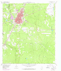
The San Jacinto Liberty Co boundary line bisects this landscape, where the Sam Houston National Forest meets an expanding industrial and residential hub. Cleveland serves as the focal point, defined by a dense grid of streets like Washington Ave and Rusk ST, and anchored by community institutions including Leggett Memorial Hospital and a dedicated Library. The town's economy is clearly tied to the land, situated between the East Fork San Jacinto River and the extensive marshlands to the east.
Find a feature on this map
45 named features on this map. Tap any name to fly to it.
Don’t see what you’re looking for? This feature index may not catch every label — zoom into the map to look around manually.
Map Details
Editions of this 1958 Cleveland Map
2 editions found
Other maps of this area

1943 · Liberty
USGS Topo · 1:125,000

1954 · Beaumont
USGS Topo · 1:250,000

1955 · Rayburn
USGS Topo · 1:62,500

1955 · Liberty
USGS Topo · 1:62,500

1957 · Beaumont
USGS Topo · 1:250,000

1958 · Fostoria
USGS Topo · 1:24,000

1958 · Westcott
USGS Topo · 1:24,000

1958 · Bear Creek
USGS Topo · 1:24,000

1959 · Plum Grove
USGS Topo · 1:24,000
1959 · Splendora
USGS Topo · 1:24,000