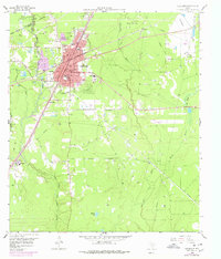
1958 Map of Cleveland
USGS Topo · Published 1978About this map
Cleveland serves as a significant East Texas junction where the Southern Pacific and Atchison Topeka and Santa Fe railroads intersect near the East Fork San Jacinto River. The landscape is defined by the extraction economy of the mid-20th century, with the sprawling South Cleveland Oil Field and the Pelican Oil Field dominating the southern and northern sectors. Local civic life is anchored by institutions like Leggett Memorial Hospital, North Side Sch, and South Side Sch, while the rural fringes are dotted with gathering places such as New Salem Ch and Grace Ch. To the northwest, the Sam Houston National Forest boundary meets the small settlement of Grady, illustrating the edge of the timbered wilderness. This edition includes 1970s revisions that show the outward urban expansion of the town center alongside established family landmarks like Allan Pond.
Find a feature on this map
41 named features on this map. Tap any name to fly to it.
Don’t see what you’re looking for? This feature index may not catch every label — zoom into the map to look around manually.
Map Details
Editions of this 1958 Cleveland Map
2 editions found
Other maps of this area

1943 · Liberty
USGS Topo · 1:125,000

1954 · Beaumont
USGS Topo · 1:250,000

1955 · Rayburn
USGS Topo · 1:62,500

1955 · Liberty
USGS Topo · 1:62,500

1957 · Beaumont
USGS Topo · 1:250,000

1958 · Fostoria
USGS Topo · 1:24,000

1958 · Cleveland
USGS Topo · 1:24,000

1958 · Westcott
USGS Topo · 1:24,000

1958 · Bear Creek
USGS Topo · 1:24,000

1959 · Plum Grove
USGS Topo · 1:24,000