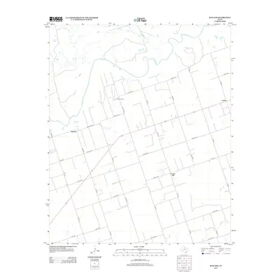
2012 Map of Rayland
USGS Topo · Published 2012About this map
Pease River meanders across the northern portion of this Wilbarger County landscape, providing a natural boundary for the agricultural grid that defines the region. Near the river’s edge, Antelope Springs offers a rare named water source in this semi-arid terrain. The small community of Rayland and the settlement of Lockett serve as local hubs for the surrounding ranching and farming operations, connected by a network of county roads such as Old River Rd and Ranch Road 98.
Find a feature on this map
32 named features on this map. Tap any name to fly to it.
Don’t see what you’re looking for? This feature index may not catch every label — zoom into the map to look around manually.
Map Details
Editions of this 2012 Rayland Map
This is the sole edition of this map. No revisions or reprints were ever made.
Other maps of this area

1954 · Wichita Falls
USGS Topo · 1:250,000

1955 · Lawton
USGS Topo · 1:250,000

1958 · Wichita Falls
USGS Topo · 1:250,000

1958 · Vernon
USGS Topo · 1:62,500

1958 · Medicine Mound
USGS Topo · 1:62,500

1966 · Santa Rosa Lake
USGS Topo · 1:24,000

1966 · Thalia
USGS Topo · 1:24,000
1966 · Santa Rosa Lake NW
USGS Topo · 1:24,000

1983 · Warrior Hollow
USGS Topo · 1:24,000

1983 · Tolbert
USGS Topo · 1:24,000