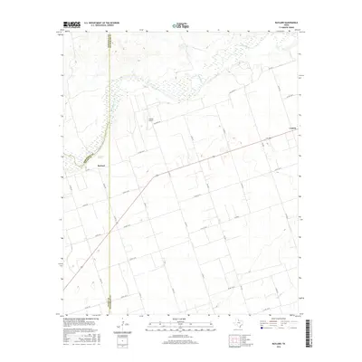
2016 Map of Rayland
USGS Topo · Published 2016About this map
The Pease River carves a winding path across the northern reaches of this West Texas landscape, where the borders of Hardeman, Foard, and Wilbarger Counties converge. This agricultural region is defined by a dense grid of rural corridors and ranch roads, punctuated by the small settlement of Rayland and the community of Lockett to the east. Along the river valley, features like Antelope Springs indicate the vital role of water in this semi-arid terrain. The inclusion of Lehman Airport and a vast network of farm-to-market roads, including FM 1207 and FM 2073, reflects the modern infrastructure supporting the area's sprawling ranchlands and farm fields. Geographers and local historians can trace the transition from the braided riverbed in the north to the upland drainage of Paradise Cr in the south, following the historic paths of Old River Rd through the plains.
Find a feature on this map
32 named features on this map. Tap any name to fly to it.
Don’t see what you’re looking for? This feature index may not catch every label — zoom into the map to look around manually.
Map Details
Editions of this 2016 Rayland Map
This is the sole edition of this map. No revisions or reprints were ever made.
Other maps of this area

1954 · Wichita Falls
USGS Topo · 1:250,000

1955 · Lawton
USGS Topo · 1:250,000

1958 · Wichita Falls
USGS Topo · 1:250,000

1958 · Vernon
USGS Topo · 1:62,500

1958 · Medicine Mound
USGS Topo · 1:62,500

1966 · Santa Rosa Lake
USGS Topo · 1:24,000

1966 · Thalia
USGS Topo · 1:24,000
1966 · Santa Rosa Lake NW
USGS Topo · 1:24,000

1983 · Warrior Hollow
USGS Topo · 1:24,000

1983 · Tolbert
USGS Topo · 1:24,000