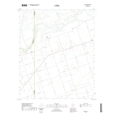
2019 Map of Rayland
USGS Topo · Published 2019About this map
Pease River meanders across the northern reaches of this landscape, marking a shifting natural boundary where Hardeman, Foard, and Wilbarger counties converge. The terrain is defined by wide river bottoms and the intermittent flow of Paradise Cr, situated in a region traditionally dominated by ranching and cotton farming. Settlement is concentrated around the small community of Rayland and the crossroads at Lockett, connected by a geometric grid of rural roads like Old River Rd and several farm-to-market routes. Local aviation is represented by the privately-held Lehman Airport, while Antelope Springs provides a rare named water source near the riverbank. This survey reflects the modern agricultural character of North Texas, where large land tracts and straight-line county roads persist as the primary infrastructure.
Find a feature on this map
34 named features on this map. Tap any name to fly to it.
Don’t see what you’re looking for? This feature index may not catch every label — zoom into the map to look around manually.
Map Details
Editions of this 2019 Rayland Map
This is the sole edition of this map. No revisions or reprints were ever made.
Other maps of this area

1954 · Wichita Falls
USGS Topo · 1:250,000

1955 · Lawton
USGS Topo · 1:250,000

1958 · Wichita Falls
USGS Topo · 1:250,000

1958 · Vernon
USGS Topo · 1:62,500

1958 · Medicine Mound
USGS Topo · 1:62,500

1966 · Santa Rosa Lake
USGS Topo · 1:24,000

1966 · Thalia
USGS Topo · 1:24,000
1966 · Santa Rosa Lake NW
USGS Topo · 1:24,000

1983 · Warrior Hollow
USGS Topo · 1:24,000

1983 · Tolbert
USGS Topo · 1:24,000