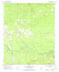
1970 Map of Reader
USGS Topo · Published 1977About this map
The Little Missouri River snakes across this 1970s landscape, defining the jagged boundaries of Clark, Nevada, and Ouachita counties. This riverine environment is characterized by a complex network of sloughs and bends, including Minnie Slough, Bolin Slough, and the prominent Horseshoe Bend. The settlement pattern is anchored by the community of Reader in the south and Whelan Springs to the west, connected by the Missouri Pacific and the Reader Railroad.
Find a feature on this map
48 named features on this map. Tap any name to fly to it.
Don’t see what you’re looking for? This feature index may not catch every label — zoom into the map to look around manually.
Map Details
Editions of this 1970 Reader Map
2 editions found
Other maps of this area

1901 · Gurdon
USGS Topo · 1:125,000

1903 · Camden
USGS Topo · 1:125,000

1953 · El Dorado
USGS Topo · 1:250,000

1957 · El Dorado
USGS Topo · 1:250,000

1958 · El Dorado
USGS Topo · 1:250,000

1960 · El Dorado
USGS Topo · 1:250,000

1970 · Whelen Springs
USGS Topo · 1:24,000

1970 · Reader
USGS Topo · 1:24,000
1970 · Gurdon
USGS Topo · 1:24,000
1970 · Curtis
USGS Topo · 1:24,000