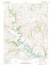
1971 Map of Reading
USGS Topo · Published 1972About this map
The Marais Des Cygnes River meanders through this landscape on the border of Lyon and Osage counties, just as the Melvern Reservoir was being established in the early 1970s. The town of Reading serves as a local hub, situated where Mud Creek meets the river's floodplain. The infrastructure of the Atchison Topeka and Santa Fe railroad corridor is a dominant feature, cutting across the terrain toward the settlement of Barclay. Genealogists will find several burial sites preserved on this sheet, including Reading Cem, Barclay Cem, and Mt Calvary Cem. The hydrology is particularly intricate here, with named tributaries like One Hundred and Fortytwo Mile Creek, Duck Creek, and Standifred Creek carving through the townships of Reading, Barclay, and Arvonia. Evidence of local industry appears in the form of a Gravel Pit and a Gaging Station monitoring the river's flow.
Find a feature on this map
25 named features on this map. Tap any name to fly to it.
Don’t see what you’re looking for? This feature index may not catch every label — zoom into the map to look around manually.
Map Details
Editions of this 1971 Reading Map
This is the sole edition of this map. No revisions or reprints were ever made.
Other maps of this area

1885 · Eskridge
USGS Topo · 1:125,000

1885 · Burlington
USGS Topo · 1:125,000

1888 · Emporia
USGS Topo · 1:125,000

1889 · Burlingame
USGS Topo · 1:125,000

1889 · Eskridge
USGS Topo · 1:125,000

1894 · Emporia
USGS Topo · 1:125,000

1894 · Eskridge
USGS Topo · 1:125,000

1894 · Burlingame
USGS Topo · 1:125,000

1894 · Burlington
USGS Topo · 1:125,000

1947 · Lawrence
USGS Topo · 1:250,000