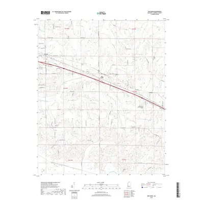
2018 Map of Red Banks
USGS Topo · Published 2018About this map
Red Banks serves as a central hub in this part of Marshall County, situated along a primary transportation corridor that includes a major railroad line and highway. The settlement pattern here is closely tied to the land's hydrology, with Victoria and Mahon anchored near the watercourses of Barrow Creek and Red Banks Creek. A significant engineering feature is the Red Banks Creek Canal, which indicates historical efforts to manage drainage and land use in this low-lying region. For those researching family history, the landscape is dotted with several small burial grounds, such as McCraven Cemetery and Wesley Chapel Cemetery, which often mark the sites of early communities or family homesteads. The Holly Springs-Marshall County Airport stands as a more modern landmark amidst the older rural road networks like Kizer Mountain Road and Rabbit Ridge Road.
Find a feature on this map
84 named features on this map. Tap any name to fly to it.
Don’t see what you’re looking for? This feature index may not catch every label — zoom into the map to look around manually.
Map Details
Editions of this 2018 Red Banks Map
This is the sole edition of this map. No revisions or reprints were ever made.
Other maps of this area

1944 · Tyro
USGS Topo · 1:62,500

1944 · Potts Camp
USGS Topo · 1:62,500

1945 · Potts Camp
USGS Topo · 1:62,500

1948 · Byhalia
USGS Topo · 1:62,500

1953 · Holly Springs
USGS Topo · 1:62,500

1956 · Tupelo
USGS Topo · 1:250,000

1958 · Tupelo
USGS Topo · 1:250,000

1964 · Waterford
USGS Topo · 1:24,000
1965 · Slayden
USGS Topo · 1:24,000
1965 · Holly Springs
USGS Topo · 1:24,000