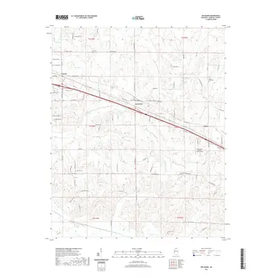
2021 Map of Red Banks
USGS Topo · Published 2021About this map
Victoria and Red Banks anchor this North Mississippi landscape in Marshall County, illustrating a rural community defined by its drainage basins and historic burial grounds. The terrain is deeply etched by a network of waterways including Byhalia Cr in the north and Pigeon Roost Creek along the southern border. This modern survey reveals how local transport and infrastructure, such as the Holly Springs- Marshall County Airport, integrate with long-standing family and community landmarks. Genealogists will find a high density of rural cemeteries, including Brick Cem, Wesley Chapel Cem, and McCraven Cem, often located near the winding tracks of Rabbit Ridge Rd and Old Hernando Rd. The map also traces the smaller settlement of Mahon and the course of Red Banks Cr, showing a distribution of homes and farms that remains consistent with the area's agricultural roots.
Find a feature on this map
81 named features on this map. Tap any name to fly to it.
Don’t see what you’re looking for? This feature index may not catch every label — zoom into the map to look around manually.
Map Details
Editions of this 2021 Red Banks Map
This is the sole edition of this map. No revisions or reprints were ever made.
Other maps of this area

1944 · Tyro
USGS Topo · 1:62,500

1944 · Potts Camp
USGS Topo · 1:62,500

1945 · Potts Camp
USGS Topo · 1:62,500

1948 · Byhalia
USGS Topo · 1:62,500

1953 · Holly Springs
USGS Topo · 1:62,500

1956 · Tupelo
USGS Topo · 1:250,000

1958 · Tupelo
USGS Topo · 1:250,000

1964 · Waterford
USGS Topo · 1:24,000
1965 · Slayden
USGS Topo · 1:24,000
1965 · Holly Springs
USGS Topo · 1:24,000